Home>A collaboration between historical research and cartography: a look back at a partnership at Sciences Po’s Cartography Workshop

11 June 2026

A collaboration between historical research and cartography: a look back at a partnership at Sciences Po’s Cartography Workshop

Section #article

A collaboration born out of the Cartography Workshop

The collaboration between Amy Hoube, a Master’s student in History (supervised by Guillaume Piketty), and Benoît Martin, a PhD holder in Political Science and cartographer at the Sciences Po Cartography Workshop, developed within the framework of the monthly workshops offered to students, lecturers and researchers.

These support sessions aim to assist with data processing and visualisation in ongoing research, by providing methodological tools tailored to the needs of individual projects.

It was within this framework that the idea arose to participate in the annual conference of the MATE-SHS network, dedicated this year to the theme: “The visualisation of time and space”.

“While discussing my topic with Mr Martin, he pointed me towards a call for papers that perfectly matched my chapter and the maps I was developing.”
Amy Hoube, Master’s student in History

A scientific co-production project under tight deadlines

The project was organised within a particularly short timeframe of around two weeks, covering the design of the poster, the structuring of the data and the cartographic production.

“The call for papers arrived shortly before the deadline. It was a very tight schedule, which required intensive and coordinated work.”
Benoît Martin, PhD in Political Science and cartographer at the Sciences Po Cartography Workshop

This tight timeframe led to close collaboration between the student and the Cartography Workshop, going beyond the usual scope of ad hoc support.

Cartography as a tool for historical analysis

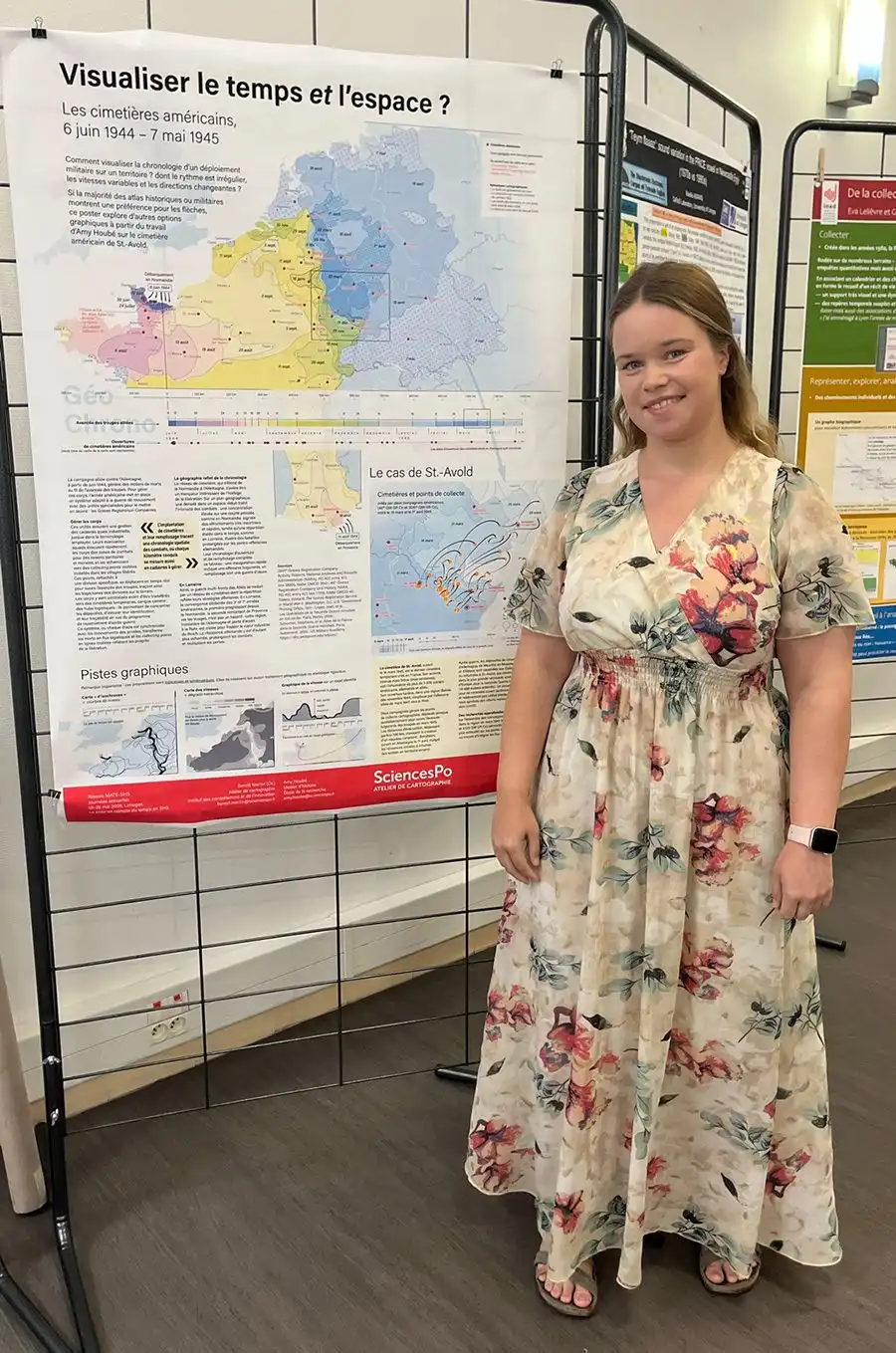
The project focuses on the management of bodies and the burial practices of American forces during the Second World War, particularly in the context of the military advance in Western Europe.

The analysis is based on linking two dimensions: the spatial progression of the troops and the temporal sequence of military operations.

“The systems for evacuating and burying bodies directly follow the evolution of the front line and allow us to interpret the spatial and temporal dynamics of the conflict together.”
Amy Hoube

This approach makes it possible to reveal organisational and logistical patterns that are often difficult to grasp from archival sources alone.

“The challenge is to represent both space and time simultaneously, incorporating the variations in the pace of military advance, including both its accelerations and decelerations.”
Benoît Martin

A collaboration between technical workshop and social science research

The creation of the poster and maps was based on a division of tasks between the student and the Cartography Workshop.

Amy Hoube was responsible for structuring the data, building the databases required for cartographic production, and drafting a summary text to accompany the visualisations.

“I built a database and gathered the elements needed to produce the maps, as well as a text presenting my chapter. ”
Amy Hoube

The Cartography Workshop then took charge of the graphic design and the production of the cartographic representations.

“This is a relatively unprecedented co-production on this scale within the framework of the monthly workshops, which usually involve one-off support.”
Benoît Martin

This collaboration is in line with the remit of the Institute for Skills and Innovation (ICI), which encourages cross-disciplinary approaches and supports Sciences Po’s academic communities.

A first participation in a scientific conference

Participating in the MATE-SHS conference marks Amy Hoube’s first experience of scientific communication, ahead of the defence of her dissertation.

“This is my first time presenting at a conference. It is an experience that is both impressive and formative.”
Amy Hoube

This participation also opens up prospects for further research, particularly within the framework of a doctoral project on funeral practices in wartime contexts, with a comparative and international dimension.

Outlook

This experience illustrates the growing role of mapping tools in humanities and social sciences research, not only as a means of dissemination but also as instruments for analysis and knowledge production.

It highlights the value of collaborations between researchers and specialist technical organisations, fostering the emergence of hybrid research approaches at the interface between data, spatialisation and historical timeframes.


Amy Hoube devant le poster réalisé en collaboration avec l'atelier de cartographie de Sciences Po pour les journées MATE-SHS
Martin Benoît, Hoube Amy - Atelier de cartographie de Sciences Po ( France)

This poster, produced by the Sciences Po Cartography Workshop as part of a project supporting a Master’s student in history research, presents a number of graphical and cartographic visualisations of the chronological dimension (the gradual liberation of Western Europe by the Allies, the opening of cemeteries and their “operation” in Lorraine) combined with that of geographical space. The rapid and combined visualisation of both is not straightforward, particularly when the pace is irregular, the speeds vary and the geography is variable. Visualising time and space? American cemeteries, 6 June 1944 – 7 May 1945.

Source

Section #interview

A joint interview with Amy Hoube and Benoît Martin

Could you briefly introduce yourself and explain how your collaboration on this project came about?

Amy: "I had applied for assistance from the mapping workshop to create maps for my dissertation, which focuses on American funeral and commemorative practices and the handling of bodies by the United States during the Second World War, with a case study on the American cemetery at Saint-Avold in Lorraine (supervised by Guillaume Piketty).

The monthly workshop takes place one Thursday a month and it was Mr Martin who looked after me. Whilst discussing my topic to gather as much information as possible for creating the maps, he told me about a call for applications for a conference on the visualisation of time and space in the humanities and social sciences, and we realised that my chapter and my maps fitted this theme perfectly.

We then produced the poster and the maps in about a fortnight, before revising the work so that it could be incorporated into my thesis.‘

Benoît: ’The Cartography Workshop organises monthly ‘workshops’ open to students, lecturers or researchers seeking guidance on processing and visualising their data. The formats vary widely: the main aim is to troubleshoot, provide guidance, or suggest cartographic methods suited to ongoing research.

In Amy’s case, I spotted a call for papers for the MATE-SHS conference on the visualisation of time and space, and I thought her work would fit in perfectly. The idea of producing a poster came about quite naturally.

The schedule was very tight, however, as we were just a few days away from the submission deadline. This led to an intense, almost frantic, effort to produce the maps on time. But Amy fully understood what was at stake, and we managed to carry out this collaboration efficiently and quickly.

How does your research topic fit within the theme of ‘visualising time and space’?

Amy: "The first chapter of my thesis focuses on the management of bodies during the war – a war of movement – from the Normandy landings until the end of hostilities in Europe.

The aim is to show how funeral practices adapted to this military context: bodies had to be evacuated quickly, gathered at collection points, then buried temporarily before being transferred to permanent cemeteries. These arrangements thus followed the advance of the troops.

When distances became too great, new cemeteries were created. This allows us to trace the military advance spatially, but also its temporality through the dates of opening and closing.

As we put it on the poster: “The establishment of cemeteries and their filling trace a spatial chronology of the fighting, where every kilometre conquered is also measured in bodies to be managed. ‘

The case of the Saint-Avold cemetery is particularly telling, as it was open for only three weeks due to the very rapid advance of the troops.’

Benoît: "Mapping is an essential tool for historians, even if its use is sometimes less visible than its role in disseminating knowledge, particularly through atlases.

In the case of Amy’s work, the main challenge is to represent two dimensions simultaneously: space, with the advance of Allied troops, and time, with the speed (or sometimes the slowness, or even the halts and retreats) of this progress.

This type of representation is particularly stimulating because it forces us to consider together dynamics that do not naturally overlap. The poster does not offer a single answer, but explores several avenues of representation, some of which are fairly conventional in cartography.

It is also a demanding exercise: in data visualisation, clarity is essential, but it can sometimes oversimplify complex phenomena. A balance must therefore be struck between readability and fidelity to historical dynamics."

What role did cartography play in this work, and how does it specifically contribute to your analysis?

Amy: "Mapping first helped me to better understand my own subject. The archives list information, but visualising it spatially completely changes one’s perception of the dynamics.

Seeing the collection points and how they evolved in relation to the advance of the troops helped me understand just how much the management of bodies was shaped by the war itself.

What was already striking in the sources becomes even clearer and more evident through the maps. I think this can also be very illuminating for the reader.‘

Benoît: ’Mapping is both a research tool and a means of dissemination. Whilst its role in publication is well known, particularly through atlases, its use during research is just as important.

In this work, it allows us to link two essential dimensions: the spatial progression of military advances and the temporal nature of operations, with their accelerations, slowdowns, and occasional interruptions.

It is precisely this interconnection that makes the analysis more nuanced and intuitive."

How did this collaboration between the research team and the mapping workshop go, and what did each of you take away from it?

Amy: "I was responsible for compiling the data into a structured database, along with existing maps from atlases, to enable the creation of visualisations.

I also wrote a text in French to introduce my chapter and explain the relevance of my topic within the context of the time/space theme, as my dissertation was written in English.

It was a very rewarding experience, even though some of the verification stages were complex, particularly because of the many places with the same name, which sometimes made pinpointing locations difficult.

But the end result is very satisfying: seeing the maps take shape is impressive, especially as this is my first project of this kind. I also discovered a field I knew little about, and I learnt a great deal through the workshop.

I am very grateful to have been able to collaborate with Mr Martin, who placed his trust in my work and supported me throughout this project.‘

Benoît: ’Working with Amy went very smoothly, despite a very tight schedule.

In fact, to my knowledge, this is the first time a monthly workshop has resulted in such a polished output, going beyond mere ad-hoc support. This was a genuine co-production between the Cartography Workshop and the School of Research, with a presentation in an academic setting.

If this collaboration has enabled a young researcher to present her work under favourable conditions, then the objective has been fully achieved.

This is also in line with the Atelier’s mission and, more broadly, with the DNA of the Institute for Skills and Innovation (ICI): to provide cross-disciplinary support to the various communities at Sciences Po."

What does taking part in the MATE-SHS conference mean to you, and what opportunities does it open up for your future career?

Amy: "This will be my first time presenting at a one-day conference. It’s both exciting and a little nerve-wracking, especially as I won’t have defended my dissertation by then.

But above all, it’s a very stimulating experience. I’m looking forward to discovering the work of the other participants and discussing ideas with researchers from different areas of history.

I hope this will be the start of a career in research. I’d like to continue my work on the management of bodies by doing a PhD, probably abroad, for example in Australia or the United States, so that I can continue to study American practices or adopt a comparative perspective.

The Pacific theatre of operations, in particular, remains understudied in this regard, which opens up some interesting avenues.”

Section #Find out more

(credits: Amy Hoube )

Virtual Graduate Open House day, October 2025

Graduate Open House Day

On 17 October 2026: meet faculty members, students and representatives and learn more about our 30 Master's programmes.

Sign-up