Our knowledge of Russia and the USSR is no longer in focus. That is the conclusion delivered here by three researchers who offer us a historiographical overview of painting, film, architecture, and urban planning. In their company, we exit a history centered around the decryption of ideological messages effectively imposed by the state apparatus. It is henceforth a question of artistic practices, commissions, markets, sales and resales, distribution, ways of exhibiting works, audiences, and artworks that avoid the model of propagandistic rhetoric out of a concern, in particular, for economic profitability. This economic question thus weighs heavily on everything, including fields in which this dimension had been left out under the pretext that capitalism had officially been banished.
Laurence Bertrand Dorléac
Urban Planning During the Stalinist Period Tested by Economic Reality
Elisabeth Essaïan
In his contribution to a work entitled L’architecture des régimes totalitaires face à la démocratisation, Yannis Tsiomis has pointed out the ambiguities that are contained in the notion of totalitarian architecture:
“What is totalitarian architecture? Is it the architecture of a totalitarian regime? Is it a kind of architecture in which monumentality prevails? Is it the kind that selects certain styles at the expense of other ones? In short, is this a political question, a spatial doxology of power or the regime, a question of size . . . or a stylistic question?”[ref]Yannis Tsiomis, “Architecture totalitaire ou discours totalitaires sur l’architecture?” in Ioana Iosa, ed., L’architecture des régimes totalitaires face à la démocratisation (Paris: Éditions de l’Harmattan, 2008), p. 32.[/ref]
While these salutary questions allow one to set the boundaries for the more general notion of totalitarian art,[ref]This notion received renewed interest after the publication of Igor Golomshtok’s 1990 work Totalitarian Art in the Soviet Union, the Third Reich, Fascist Italy and the People’s Republic of China, trans. from the Russian by Robert Chandler (New York, NY: Icon Editions, 1990) and Boris Groys’s 1988 work The Total Art of Stalinism: Avant-garde, Aesthetic Dictatorship, and Beyond, trans. Charles Rougle (Princeton, NJ: Princeton University Press, 1992).[/ref] there are two other aspects of the issue that seem to me essential for an understanding of architectural and urban production during the Stalinist period.
Indeed, by looking too closely into the symbolic and ideological dimensions of such architectural production, one ends up neglecting the economic framework and the role that framework could play in the implementation and definition of the form. Furthermore, reading such production only through its most noteworthy objects, whether they remained simply on paper or were actually expressed “in stone” (the Palace of the Soviets, the Moscow subway system, the very tall buildings of the postwar period), one ends up forgetting that cities are made up not only of projects and monuments and that they are complex objects with multiple temporalities, materials, scales, and agents.[ref]See, on this issue, the work of Massimiliano Roncayolo, Pier Giorgio Gerosa, Bernard Lepetit, and André Corboz, in particular Roncayolo’s Lectures de villes. Formes et temporalités (Marseilles: Parenthèses, 2002) and Gerosa’s Eléments pour une historie des théories sur la ville comme artefact et forme spatiale (XVIIIe- XXe s.) (Strasbourg: Université des Sciences Humaines, 1992).[/ref]
Shifting one’s gaze from symbolic and ideological questions toward the economic question and from the architectural object toward the city-as-object, one is better able to investigate the specificities not only of the form of such production but also of its frame as well as the relation between frame and form.
If it needs to be recalled, let us repeat that the cost of creating an architectural object is much greater than that of creating any other kind of object in the field of art. And to transform the city-as-object costs even more. As François Moriconi-Ebrard has underscored:
“[T]he temporalities of a metropolitan area are known for their longevity: bricks, stone, asphalt, concrete, water mains, and rail lines are made to last. The installation of an urban space is quite costly and, in the absence of war or of exceptional or unforeseeable catastrophes, it can be replaced only a little bit at a time.”[ref]François Moriconi-Ebrard, De Babylone à Tokyo. Les grandes agglomérations du monde (Paris: Éditions Ophrys, 2000), p.22.[/ref]
What urban-planning project, except for those executed ex nihilo, has not been confronted by such a situation and been forced to adapt to it? Was the main urban-planning project of the Stalinist period, the Moscow reconstruction plan of 1935, an exception to the rule?
Designed within the context of a specific political regime wherein the state takeover of production was, if not complete, at least quite extensive, this project was developed inside the State’s planning offices, a highly hierarchized structure that brought together the main “architectural forces” of the country. But it depended above all on some unique conditions many urban planners and architects dream of: the absence of private ownership of land and of real property.[ref]5Decrees of November 8 (October 26), 1917 and August 20, 1918.[/ref]
Did those exceptional frameworks and conditions render the fulfillment of this urban-planning project any simpler for all that? Did they ensure that the transition from project to finished object would be any more faithful? Did they lead to the emergence of a specific urban form?
By observing the way in which one of the essential components of this urban-planning project–the kvartal/maguistral (city block/main artery) pair–was set in place, one can better understand this relationship that pertains to the many changes that take place between project design and completed object.
Kvartal / maguistral : A Privileged Pair for Observation
On the one hand, the Moscow reconstruction plan was designed to be implemented on a large territorial scale as it envisioned a doubling of surface area, the creation of new systems (green zones, river use, and transport), and a tripling of the number of the square meters set aside for housing. On the other hand, it was based on the idea of preserving the city’s radioconcentric structure, whose layout was in fact to be reinforced by the cutting of new radial and concentric arteries as well as the enlargement of existing roads. Paralleling the large scale of the operation, the basic unit of this development plan was defined as the kvartal (city block), land parcels having ceased, in the absence of private ownership of land, to fill the role of the smallest unit for urban division.
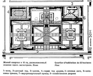
Fig. 1 Blueprint for an ideal kvartal of 15 hectares. 1. day-care center; 2. playground; 3. school; 4. parking lot; 5. parking spaces; 6. streetcar stops; 7. walkway; 8. courtyard.
While the average size of the historic city block in central Moscow was up to three hectares, the plan defined a new block as 10 to 15 hectares. This surface area was directly tied to issues relating to transportation, pedestrian movement, and the definition of new standard sizes for roads. In fact, the outer edge of the kvartal was to measure 500 meters, a length that, according to the designers, would constitute the ideal distance between two intersections. Indeed, it would allow one to maintain traffic flow without generating the risks associated with speeding cars, while the inhabitant of the kvartal would have to travel only a maximum of 250 meters on foot in order to reach the corners of the block (image 1).
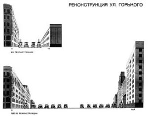
Fig. 2 Drawing for the widening of Gorky Street. 1938.
Residential buildings six or seven floors high were laid out at the perimeter to surround a large central square. At the center of the kvartal, buildings of a lesser height were to be included, ones intended for such local facilities as daycare centers, schools, and playgrounds. Shops were placed on the ground floor, facing the street. Access to housing units was from the courtyard side, which could be reached by going through monumental arches cut into the first two or three floors of the residential buildings (image 2). With a planned population density of 400 inhabitants per hectare, these large kvartaly were to receive 4,000 to 6,000 inhabitants, the latter figure never having been announced.
The city would therefore be divided into large urban units of 10 to 15 hectares organized around planted courtyards and separated by radial and concentric arteries whose width would vary, as a function of their importance, from 50 to 120 meters, the whole layout being interrupted at regular intervals by vast squares.
When the Existing City Redesigns the Project
The pages of professional journals from this period are filled with projects that applied these principles within the historic city center, the priority area for reconstruction. Drawn upon the background of the old land registry–this figurative mode affording them a sense of technical realism–these proposed projects led people to believe that there would be a radical destruction of the old city fabric.
And yet a look at the fabric of Gorky (now Tverskaya) Street, the first large construction site and the city’s main artery since the seventeenth century, reveals that the original ambitions had been revised downward, unless those apparently realistic projects are to be classified as idealized representations.

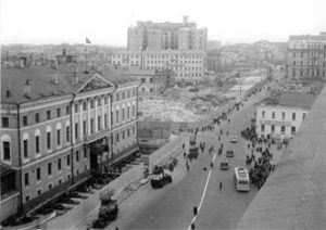
Fig. 3 Sovietskaya (Tverskaya) Square), Mossoviet building being moved. 1939. Shchoussev Museum).
The street was certainly doubled in width, passing from 18 meters to 40 meters–but not to the 60 meters initially planned. The Sovietskaya (now Tverskaya) Square was enlarged, but to a lesser extent than what the published plans (image 3) had led one to imagine. At the same time, those monumental arches opened behind the new facades, not on a large planted space, but on a dense fabric of old buildings and irregularly traced alleys. Although the parcel or tract of land would no longer be an expression of private property ownership, it continued to be materialized in physical form through numerous fence enclosures and walls. As for the old land registry, it did not serve solely as the background for future projects, the better to illustrate the transformations being proposed, but as a prop that allowed one to inventory existing buildings, with registrations being made on the parcel level. Finally, although we have at our disposal no document that would attest to the precise number of people inhabiting those central city neighborhoods, it is highly unlikely that the density of the kvartal would have been able to be maintained at 400 inhabitants per hectare. The existence of the housing crisis at the time, which peaked during the years 1934-1955 with an average of four square meters per inhabitant, would lead one to believe, rather, that population density was two times higher. As for the new housing units designed for those buildings, though they were individual units on paper, they were in large part transformed into communal apartments. Their arrangement around a large and broad central corridor facilitated their subdivision.
Kvartal / maguistral?: How Economics Reveals Symbolics
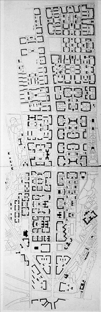
Fig. 4. Southwest neighborhood. 1953-1957. Initial drawing and current aerial photograph
The application of the kvartal model within the historic city center was thus not carried out in conformity with the project plan as it was originally conceived and designed. The gap between the project and its application is to be explained above all in economic terms. On the one hand, the housing crisis was such that one could not consider demolishing existing buildings, even dilapidated ones, that might serve as shelter. On the other hand, the expropriations conducted as this project plan was being implemented obliged the State to indemnify a portion of those being expropriated[ref]In reality, only inhabitants who had a propiska (recorded document) and were part of certain categories of the population had a right to such indemnifications, which consisted in a payment of 2,500 rubles, or around 10 months of average wages in 1934.[/ref], as contrasted with the uncompensated seizures of real estate that followed the Revolution of 1917.
This economic choice reveals the true symbolic choices involved, since it allows one to read what was going on in the balancing of the kvartal/maguistral pair, where the street, the facade, and the public dimension of the project prevailed over the building unit, the interior decoration, and the “intimate” sphere, for lack of a “private” one.
In fact, even though demolitions of existing buildings occurred at a less frequent rate than had been envisioned in the original project plan, they were of high visibility. Contrary to the street cuts made by Baron Haussmann, which involved low-value buildings in the middle of street blocks, the 1935 Moscow plan was aimed at enlarging existing streets and thereby led to the destruction of what was most precious, buildings facing the street. It was the likelihood of old buildings being able to be transformed or moved that determined in this case whether or not they would be preserved. Some were indeed movable, thanks to a technique developed by Americans during the nineteenth century, and among them were included some of the biggest buildings in the city: taken off their foundations, secured with a metal belt, and set on a rail, they were pushed to the back of a courtyard, on the new street line, or else rotated 90 degrees (image 4).
And even though the kvartal plan was not carried out in the historic center of the city, the creation of a long continuous facade of homogeneous size and architectural style nevertheless gives the impression, from the street side, of a successfully completed project.
Paradoxically, it was during the first years of Khrushchev’s presidency, in the midst of a debate about the economy and the standardization of construction materials and processes, that the kvartal idea was to be implemented in the closest form to the one conceived in the 1935 plan. Moscow’s southwest neighborhood, situated around the Lomonosov University, was the illustration of this (image 6). And it is perhaps through this example that one can truly speak of the emergence of a new urban form, at least on an unprecedented divisional scale.
Bibliography
Iosa, Ioana. Ed. L’architecture des régimes totalitaires face à la démocratisation. Paris: Éditions de l’Harmattan, 2008.
Essaïan, Elisabeth. Portrait de Moscou. Paris: Cité de l’architecture, 2009.
_____. Le plan général de reconstruction de Moscou, La ville, l’architecte et le politique.
Héritages culturels et pragmatisme économique. Architecture thesis. Advisor: Jean-Louis Cohen, Université de Paris-VIII, 2006. Forthcoming: Éditions Parenthèses.
Azarova, Katerina. L’appartement communautaire, L’histoire cachée du logement soviétique. Paris: Éditions du Sextan, 2007.
Bouvard, Josette. Le métro de Moscou, La construction d’un mythe soviétique. Paris: Éditions du Sextan, 2005.
Colton, Timothy. Moscow: Governing the Socialist Metropolis. Cambridge, MA and London: The Belknap Press of Harvard University Press, 1995.
Cohen, Jean-Louis. “The Moscow Plan of 1935: When Stalin Meets Haussmann.” Art and Power: Europe under the Dictators. 1930-1945. Dawn Ades, Tim Benton, et al. Ed. Pp. 246-49.
Elisabeth Essaïan is an architect with a Ph.D. in architecture whose dissertation was devoted to the Moscow General Reconstruction Plan of 1935. She has been able to conduct a variety of research studies on Soviet and post-Soviet urban planning, some of the results of which were reworked for her recent publication, Portrait de Moscow.
Essaïan has taught and continues to teach in various architecture and landscaping schools and today leads a seminar at the École des Hautes Études en Sciences Sociales devoted to the way in which architectural and urban objects are manufactured. She also teaches at the architecture school of Normandy and the City and Territories architecture school in Marne-la-Vallée.
Her main lines of research concern issues surrounding the circulation of models, the relationships among political and professional agents, the manufacturing processes for constructing cities, and, since her stay last year at the Villa Medici, the forms of craftsmanship in various artistic disciplines.